The Dashboard screen gives you further key performance indicators as on Business data at a glance. It allows you to select the data you need and to display it as you like.
General handling
|
1.Click on "Dashboard" 2.Click on "Add gadget" 3.Click on "Choose layout" 4.Right click on the gadgets title bar 5.You may also left click on the title bar
6.To actualize the data displayed click on "Refresh" 7.You may press the Ctrl key to select several lines or the Shift key to select a row of lines, copy them with Ctrl key + C and paste them for further use to Excel with Ctrl key + V. |
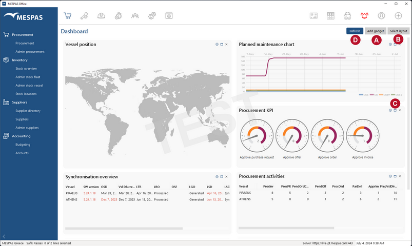
 and select the Gadgets that you like to display. Please see below for further information about the available gadgets.
 to select if you want to display the gadgets in two columns or in a single column.
 to either remove the gadget with a click on "Delete" or to change different display options for each gadget with a click on "Edit properties".

 .
Gadgets
Procurement Activities |
Shows amount of current procurement activites by vessel and activity type. The abbreviations are:
|
||||||||||||||||||||||||||||||||||||||||||||
PMS Statistics |
Shows the amount of:
- Total: Jobs for this vessel - CJ: Critical jobs - CLJ: Jobs relevant for classification society. - OD: Overdue jobs. - ODCJ: Overdue critical jobs. - ODCL: Overdue class relevant jobs. - PJ: Planned jobs (jobs which are rescheduled and not yet executed). - PJOD: Overdue Planned jobs (jobs where the reschedule date has been passed)
as per the last synchronisation by vessel. |
||||||||||||||||||||||||||||||||||||||||||||
PMS Statistics Chart |
Shows the average amount of:
- Overdue Jobs (OD), - Overdue critical jobs (ODC), - Postponed jobs (ODPP) - Overdue critical class jobs (ODCL)
on your vessels in a certain time frame as a chart.
In "Edit Properties" you can set the time frame and select which of above values to be displayed. To get the amount at a certain time move the mouse over the respective graph. Only the jobs from vessels that are selected in "My profile -> Vessels" are displayed. |
||||||||||||||||||||||||||||||||||||||||||||
Data Exchange Status |
Shows the status of automatic data imports and exports. This gadget is only relevant if you use an interface between MESPAS TSM and your Accounting Software. With a click on the relevant box you get a filter screen for past imports or exports. |
||||||||||||||||||||||||||||||||||||||||||||
Vessel Sync. Info |
Gives you detailed information about the synchronisation status of your vessels. The data provided is:
In "Edit Properties" you can set the time limit in days before there are as a warning red dates for the last receive date (LRD), the last send date (LSD), the last complete sync (LCS) and the last offline sync file date (OSD). |
||||||||||||||||||||||||||||||||||||||||||||
Last Reported Position |
Shows the last reported positions of your vessels as per the Noon report on a map. The vessels are labeled on the map with the RFQ reference number text, as set in IDM screen.
To display a vessel on the map it is mandatory that the Noon Report fields.. - Ship Pos. Lat. and - Ship Pos. Long.
...are selected in Noon report administration and filled in on board the vessel.
General data: •Vesselname •IMO number •Call Sign •Last Synchronisation date The information given from Noon Report is: •Last Noon Report date (where the information about the position is from) •Average Speed over Ground (SOG) [kt] •Main Engine HFO Consumption [mt] at sea •Main Engine MDO Consumption [mt] at sea •Remaining on board (ROB) Low Sulfur Fuel Oil (LSFO) •Remaining on board (ROB) High Sulfur Fuel Oil (HSFO) •Remaining on board (ROB) Marine Diesel Oil (MDO) •Vessel Status (in Dock, in Port, on Anchorage, Sailing) The information given from Ship schedule is: •Next Port •Expected time of arrival (ETA) •Expected time of departure (ETD)
In "Edit Properties" you can set the time limit in days since the last position was transmitted. The last position will be shown as a warning in orange or as an error notification in red. You can also deactivate the vessels track and set its time limit (1 - 99 days). |